
Wednesday, 6th October 2010
With overnight thunderstorms and the poor weather yesterday we were not hopeful of good weather. We set out straight after breakfast, at 6.45am, in full waterproofs. At the Trail Head there was a group of people preparing to descend on mules. The surface of the path was very muddy in places and churned up where the mules had been on previous days. There were still some good views despite the rain. As we descended there was thunder and lightning which drew closer before it finally left the area. We made a couple of stops before we reached Indian Gardens and passed quite a few people making their way up the path, some with very large packs, having camped at Indian Gardens. Continuing on, the path zig zagged again so that we descended quite quickly without the path being too steep. Eventually we reached the Inner Canyon and the Colorado. Here we stopped at the beach area to eat lunch. The rain stopped for a little while and there was time for a paddle in the river – at least to stand in the water close to the edge as the sand sloped down quite quickly and the current was very fast flowing. As the rain started we continued on alongside the river, but well above it. After a mile or so we reached the bridge to cross the Colorado. Our route now took us beside Angel Creek to Phantom Lodge. We soon located our cabin – with three double bunk beds and not much room between them. Marie and I then returned to the river and found another beach to have a paddle. We crossed the mule’s bridge and walked along the opposite side of the river and across the first bridge again. The evening meal was a beef stew which was quite good.
Hiking any of the trails that descend into the canyon allows you to pass through successive different landscapes, each with its own climate, wildlife, and topography. The South Rim is 7,000ft above sea level and average summer temperatures inside the canyon exceed 100˚F.
The trail switchbacks for 9.6 miles down to Phantom Ranch. Miners laid out the first section of the trail a century ago, along an old Havasupai route. It has two short tunnels in its first mile. After another mile, the wildlife starts to increase (deer, rodents and ravens). At the lush Indian Gardens almost five miles down, the trail splits to Plateau Point or down to the river via the Devil’s Corkscrew. The latter route leads through the sand dunes scattered with cactuses and down beside Garden Creek to the Colorado, which you then follow for more than a mile to Phantom Ranch.
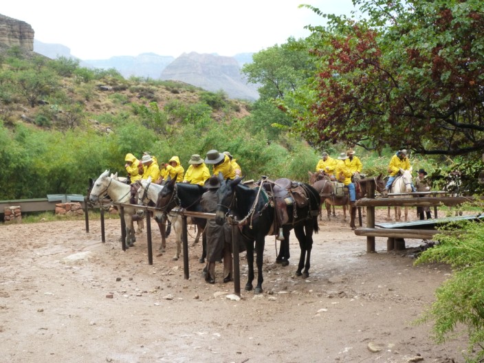
A group of riders prepare for their descent . . .

and we prepare for ours

Then we make our start . . .

with views of our route - despite the weather

Before long we meet a mule train on its way up

The zig zags help us to lose altitude quickly . . .

but the riders we saw earlier catch us up . . .

just before we reach a corral . . .
and more riders arrive from 'below'

The mules are well kitted out

Time for a snack . . .

and a chance to check that we are heading in the right direction!

The rain still falls . . .

making the path rather muddy

Approaching a vantage point . . .

we take time to take in the surroundings . . .

including a 'green gully'

The group gathers . . .
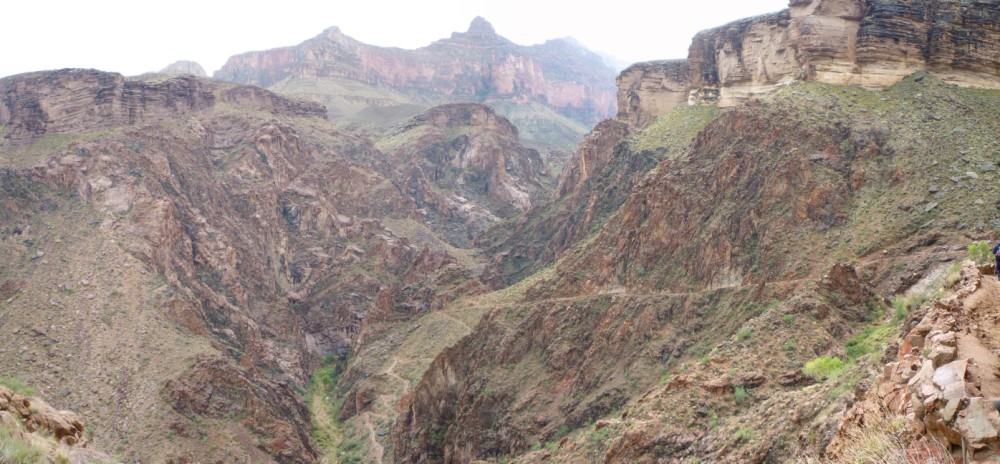
as we check out the route ahead . . .

zooming in on the mule riders

There are some quite green sections . . .

but it is rather sparse . . .

as we continue on our way . . .

along the path

More zig zags . . .

lead down to the path far below . . .

but Marie . . .

and I pause to take 'one for the album'

Once down the zig zags . . .

the group takes a short break as the weather improves . . .

and I spot a waterfall

A little while later . . .

we reach the Colorado River . . .

where Geoff and Nina pose for the camera

Despite the fast flowing water . . .

I take time out . . .

to check out how quickly the river bed descends

Lots of activity at 'the beach'

Time to move on . . .

past some colourful rocks

The path is now well above the river . . .

giving us a good view back

Our cabin at Phantom Ranch

A lizard spotted in the undergrowth . . .

finds its way onto a rock . . .

for a bit of sun bathing . . .

and giving me the opportunity to capture its 'best side'

Marie and I head back down to the river

Don't think I would fancy drinking the water!!!

Spotting another beach area . . .

time to try out the waters again

Time for a history lesson . . .

before we make our way . . .

across the bridge . . .

looking downstream . . .

and back at the bridge - with its tunnel exit

The path remains high above the river . . .

but detouring off to the side . . .

I head up a small gully . . .

to investigate . . .

and find the water seeping down the rock into small pool - could people have lived in a place like this????

The scramble didn't seem so high on the way up . . .

but I soon get back to the main path . . .

and the first bridge comes into view . . .

with its amazing cable structure

Mule deer seem to be quite tame here . . .

and this one is not worried . . .

by our presence